The area offers fantastic back road cycling opportunities through rolling farm country and wide open spaces. The surface-treated Make sure to wave at the cars and Mennonite wagons you pass as you enjoy the delights of our back roads. The distances mentioned are approximate. Except for the last suggested route, all of these routes include highways and are not recommended for small children or riders who require supervision. |
 |
General Information:
Below are cycling tours for Bruce Mines and area. Be prepared before you head out with beverages and snacks. Cell phone service is limited in some areas.
Map of the area. The Bruce Mines Chamber of Commerce brochure has a good map of the area. Copies can be obtained from the Town of Bruce Mines municipal office or from the Bruce Mines Museum. Alternatively, you can download a copy of the map here.
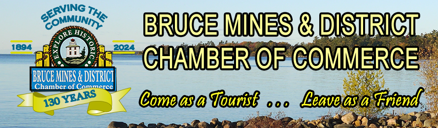
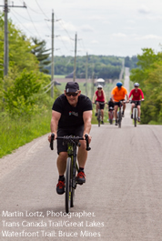
The Lake Huron North Channel Waterfront Trail will officially open in the spring of 2017 and brings cyclists into Bruce Mines from Sudbury or Sault Ste. Marie. Bruce Mines offers all amenities: accommodations, grocery store, restaurants, Royal Bank, and laundry mat. The library has computers and wifi access for a small fee. Enjoy a treat down at the waterfront or explore our quaint shops. A downloadable copy of the LHNCWT cycling map is available on the LHNCWT website. Check out sections 3, 4 and 5 for the main trail and 3A for St Joseph Island.
Bruce Mines is a good base location for avid cyclists. Here are a couple of highly recommended daytrips.
Drive 20 minutes to St Joseph Island and spend the day cycling and exploring area parks, beaches and shops. Click on the link for information on cycling tours of St Joseph Island visit, http://www.northernontario.travel/algoma-country/a-guide-to-cycling-on-st-joseph-island or look at map 3A on the waterfront trail link above.
Drive 45 minutes to Blind River and do some off road riding or hiking on the beautiful, well signed, Boom Camp Trails. This multi-season park offers 12 kilometers of packed crush limestone trails passing through 3 distinct ecologocial zones from the coastal headlands to wetlands, it has several scenic lookouts over Lake Huron and two sand beaches.
Listed below are cycling tours for Bruce Mines and the surrounding area. Be prepared before you head out and remember that Cellphone service is limited in some areas.
Items to take with you:
- Beverages and snacks
- Map of the area. The Bruce Mines Chamber of Commerce brochure has a good map of the area. Copies can be obtained from the Bruce Mines City Hall or from the Bruce Mines Museum. Alternatively you can download a copy of the map here.
Suggested Routes:
Route |
Approx Distance |
Description |
1. |
6 - 7km |
Concession 5 Road to Caribou Road: From Hwy 17, ride up Hwy 638 to Concession 5 Road. (Up the hill after the tracks). Left on to Concession 5 Road. Go to Caribou Road, turn left and it will take you back into Bruce Mines. Go down Cunningham Street to return to Hwy 17 and Bruce Mines. This loop has a combination of treated surface and gravel roads. Bike of choice - hybrid. |
2. |
9 - 10km |
Concession 5 Road to Centre Line Road: From Hwy 17, ride up Hwy 638 to Concession 5 Road. (Up the hill after the tracks). Turn left on to Concession 5 Road. Go past Caribou Road to Centre Line Road, turn left and it will take you to Hwy 17. Turn left on Hwy 17 and it is about 1 KM back to Bruce Mines. This loop has a combination of treated surface and gravel roads. Bike of choice - hybrid. |
3. |
30km |
Bruce Mines to Desbarats and back: From Bruce Mines, go west along Hwy 17 to Centre Line Road. (About 1 KM). Turn right onto Centre Line Road and follow it to Concession 5 Road. Turn left onto Concession 5 Road and proceed to Boundary Road. Turn right onto Boundary Road which at the big corner becomes Deplonty. Proceed along Deplonty to Fisher Road. Turn right onto Fisher and proceed to Government. Turn left on Government Road and follow it to Lake Huron Drive. Turn left onto Lake Huron Drive and you are in Desbarats. Return to Bruce Mines in the same manner, or on Hwy 17. Be careful of the traffic on Hwy 17. This loop has a combination of treated surface and gravel roads. Bike of choice - hybrid. |
4. |
25km |
Bruce Mines to Rydal Bank and back: From Hwy 17, ride to Rydal Bank along Hwy 638. This two lane Hwy is paved. Rolling hills with farm and bush. This loop is a 2 lane paved highway with no paved shoulders. Suitable for a road bike or hybrid. |
5. |
37 - 38km |
Voyageur Trail Bruce Mines/Debarats, Access Point A6 at the Plummer Cemetery: To get to the Plummer Cemetery – At Bruce Mines on Hwy 17, turn onto Hwy 638. Proceed approximately 10 -12kms to Rydal Bank and proceed left onto Plummer Road. Proceed 5.5 kms then turn right onto West side road for 2kms. The Plummer Cemetery is on the right. A linear off road tour on a section of the Voyageur Trail System. The bike of choice is a mountain bike or hybrid. The Voyageur trail section that runs alongside the north side of the cemetery is overgrown and has "Do not Trespass" signs posted from the local quarry. Use the access point across the road from the cemetery. It leads to a well maintained route, with a maple canopy, wide enough to ride side by side. In addition, there are numerous spur roads which offer great views of the local farms, lakes, rivers and rolling hills. You can bicycle to the cemetery from Bruce Mines or drive there and park at the cemetery. |
6. |
22 - 23km |
Cloudslee Road, East of Bruce Mines: From Hwy 17, go up Hwy 638 to Bruce Station. (3 KM) Just past Bruce Station, turn right on Cloudslee Road. It is paved and you can get as far as Little Rapids and Thessalon (19 KM. Approx) and further. Hills, forest and farm land abound. This route is not on the Bruce Mines Chamber of Commerce map. If you wish a shorter ride, about 3 KM along Cloudslee Road, turn right onto Jeffery Road. Proceed along Jeffery to Trunk Road. Turn right onto Trunk. It will take you along the back of the Trap Rock Mine. Proceed to Hwy 638, turn left and it is about 1.5KM to Hwy 17 and Bruce Mines. This loop is part of the Lake Huron North Channel Waterfront Trail System. The Loop has a combination of paved 2 lane highway, treated surface and gravel. The entire loop would be suitable for a road bike or hybrid but if you are planning for the shorter version a hybrid or mountain bike would be more suitable. |
7. |
1-2km |
Streets of Bruce Mines: Lastly, the streets of the town of Bruce Mines are paved and offer much to see for a gentle pedal about just to look at houses and scenery. People are friendly and will say hello. |
Whilst we do hope you enjoy these tours please take care when cycling routes that include the main highways. Please take special care on Hwy17 as there are big trucks travelling at high speeds.